Rehabilitation of a disused softstone quarry
Date : 1997Client : Office of the Prime Minister, Parliamentary Secretariat for Gozo

The disused softstone quarry under investigation was located on the north-western fringe of the island of Gozo; more specifically in the locality known as Tal-Ksajjem, in the limits of Għarb.
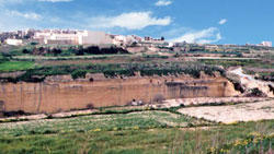
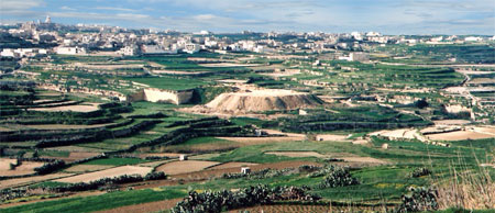
The area covered by this study was approximately 785,340 m² and included a number of major topographic features that were both natural and manmade. The single most important physical feature consisted of a dry valley system known as Wied il-Mielaħ. This, in addition to being one of the largest fluvial systems on the island, determined to a greater extent the type of land use present within the study area. In fact, the larger part of the area in question was characterised by terraced fields some of which had fallen into disuse.
Apart from the dominant agrarian element and the reclaimed quarries, the other significant topographical feature was the landfill at Tal-Ksajjem itself. The site covered an area of approximately 26,100m² and was located on a major bend of the valley bed. From this point northwards, the valley meandered across a relatively open landscape characterised by gently rolling plains and dotted with mesa landforms and associated clay taluses. The landscape was heavily dissected by a number of dry valley systems.
The rehabilitation proposal centred on landscape archaeology. It incorporated the reclamation of the site for agrarian purposes through in-filling with inert building construction waste. Where data on original contours, terracing and fields boundaries was available, it was incorporated into the restoration proposal. Where data was not available, contours and field boundaries were designed following extrapolation of data on the surrounding environs. Note was taken of the fact that since the land was sloping, fields usually followed the natural contours of the topography. Furthermore, in the case where data was not available, field sizes were kept in the range of 0.5 to 1.0 tumolo. Such sizes would be more effective against soil erosion.
Click here to download the Environmental Planning Statement.